
In today’s world, the backbone of infrastructure lies beneath our feet. Underground utilities, such as water pipes, electrical cables, and telecommunications lines, play a critical role in keeping our cities and communities running smoothly. Understanding and managing these hidden networks is vital for any construction or infrastructure project. This is where underground utility mapping becomes essential.
Underground utility mapping involves identifying the precise locations of these buried utilities. Accurate mapping helps prevent accidental damage during construction, ensures the safety of workers, and avoids service interruptions for residents and businesses. Without precise utility mapping, projects can face significant delays, increased costs, and potential hazards.
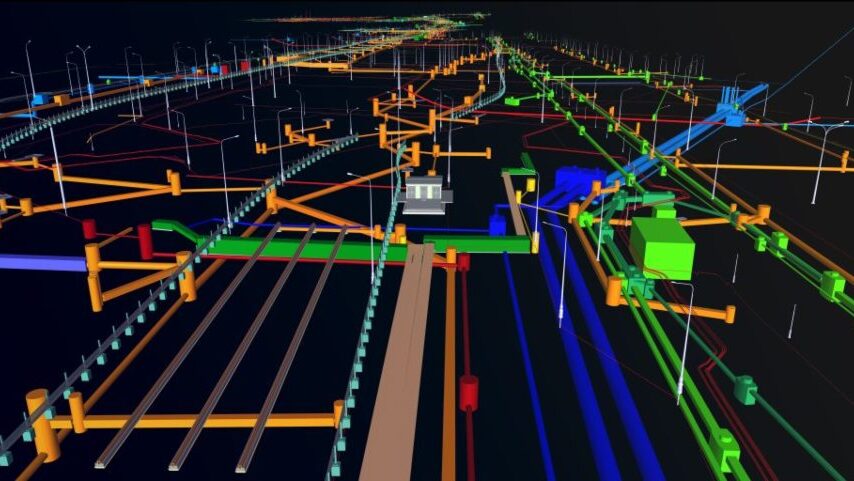
Utility mapping software is a powerful tool designed to address these challenges. This technology enables construction teams to locate and manage underground utilities with accuracy and efficiency. By using advanced techniques and tools, software-based utility mapping technology provides a clear picture of what lies beneath the ground, helping to guide excavation and construction activities safely.
Understanding utility mapping software
Mapping software for underground utilities is a specialized tool used to locate and manage underground utilities, such as water pipes, electrical cables, and telecommunications lines. The primary purpose of this software is to provide accurate and detailed maps of these hidden networks, ensuring that construction and maintenance activities can proceed safely and efficiently. By offering precise information about the location and depth of underground utilities, this software helps prevent accidental damage during excavation and construction.
How these mapping software work
Subsurface mapping software employs advanced technologies to detect and map underground utilities. These technologies include ground-penetrating radar (GPR), electromagnetic induction, and GPS.
Importance of accurate utility data collection
Accurate data collection is crucial for several reasons:
- Safety: Knowing the exact location of underground utilities helps prevent accidents that could harm workers or disrupt services. Accidental strikes on utility lines can lead to dangerous situations, such as gas leaks or electrical outages.
- Efficiency: Accurate mapping allows construction projects to proceed without unexpected delays. When teams know precisely where utilities are located, they can plan their activities more effectively, avoiding costly and time-consuming mistakes.
- Cost-savings: Preventing damage to underground utilities reduces repair costs and minimizes project delays. Accurate data collection also means fewer resources are spent on rework and emergency repairs.
Benefits of using a comprehensive utility mapping system
Improved accuracy
Accuracy is crucial in utility mapping because even a small mistake can lead to serious consequences, such as damaging utility lines, causing service disruptions, or creating safety hazards. A comprehensive mapping system uses advanced technologies like ground-penetrating radar and GPS to ensure precise data collection. This high level of accuracy significantly reduces the risk of accidental utility strikes, which can cause costly repairs and delays. By providing detailed and reliable maps of underground utilities, these systems help construction teams plan their work more effectively and avoid unexpected problems.
Enhanced compatibility
Compatibility with various devices and locators is another key benefit of a comprehensive mapping system. Construction projects often involve different tools and technologies, and seamless integration is essential for efficient operations. A robust mapping system can work with all major cable and pipe locators, ensuring that data from different sources can be combined and analyzed effectively. This integration enhances overall efficiency by allowing teams to use the best tools available without worrying about compatibility issues. It also ensures that all data is consolidated in one place, making it easier to access and interpret.
Cost savings
Using an effective utility mapping technology leads to significant cost savings. Accurate mapping reduces the likelihood of errors and delays, which can be expensive. By preventing accidental utility strikes and minimizing disruptions, projects can stay on schedule and within budget. Moreover, the improved efficiency and coordination provided by a comprehensive mapping system mean that resources are used more effectively. This optimization of project budgets and timelines translates to lower overall costs, making mapping systems a wise investment for any construction or infrastructure project.
PointMan: The ideal underground utility mapping software
PointMan is a leading underground utility mapping software designed to meet the needs of construction companies and utility operators. Its primary purpose is to provide accurate and detailed maps of underground utilities, ensuring that projects can proceed safely and efficiently. PointMan is tailored for professionals who require precise utility data to avoid costly errors and ensure the smooth execution of their projects.
PointMan’s features and capabilities
Real-time data capture
PointMan allows users to capture utility data in real time using standard mobile devices. This feature ensures that the most up-to-date information is always available, reducing the risk of errors and delays. Real-time data capture helps construction teams make immediate, informed decisions, improving overall project efficiency.
Customizable visualization
PointMan offers customizable data visualization options, enabling users to create maps and reports that suit their specific project requirements. This flexibility allows for better interpretation and analysis of utility data, helping teams to understand the underground landscape clearly and plan their work accordingly.
Collaboration tools
Effective collaboration is vital to ensure the success of any construction project. PointMan includes tools that facilitate easy sharing and collaboration among team members. This promotes transparency and ensures that all teams involved in the project have access to accurate and up-to-date utility information. By enhancing communication and coordination, PointMan helps prevent misunderstandings and reduces the likelihood of errors.
PointMan addresses several common challenges in utility mapping:
- Accuracy: By providing real-time data capture and customizable visualization, PointMan ensures precise and reliable utility maps.
- Efficiency: The software’s robust features streamline the data collection and analysis process, saving time and reducing costs.
- Safety: Accurate mapping and easy access to utility data enhance safety for workers and the public by preventing accidental utility strikes.
In summary, PointMan stands out as the ideal solution due to its robust features and capabilities. These features ensure accurate, efficient, and safe project execution. Consider using PointMan for your utility mapping needs to enhance the success and safety of your construction projects.